English| USD
Suggested for you
More currencies
Choose a language
The Islamorada sandbar occupies a shifting stretch of shallow water offshore near Mile Marker 84, accessible only by boat. Pinpointing its exact position requires understanding tidal cycles, local channel markers, and the seasonal movement of sand deposits that reshape the bottom throughout the year.
Quick answer
The Islamorada sandbar location centers approximately 1.5 nautical miles offshore from Mile Marker 84 in Islamorada, Florida, accessible only by private vessel or chartered tour. The sandbar's visible extent shifts with tidal cycles, appearing as a broad shallow flat during low tide between 08:00 and 12:00, when water depth drops to one to three feet. No entrance fee applies, but safe navigation requires local knowledge of submerged channels and shifting sand formations.
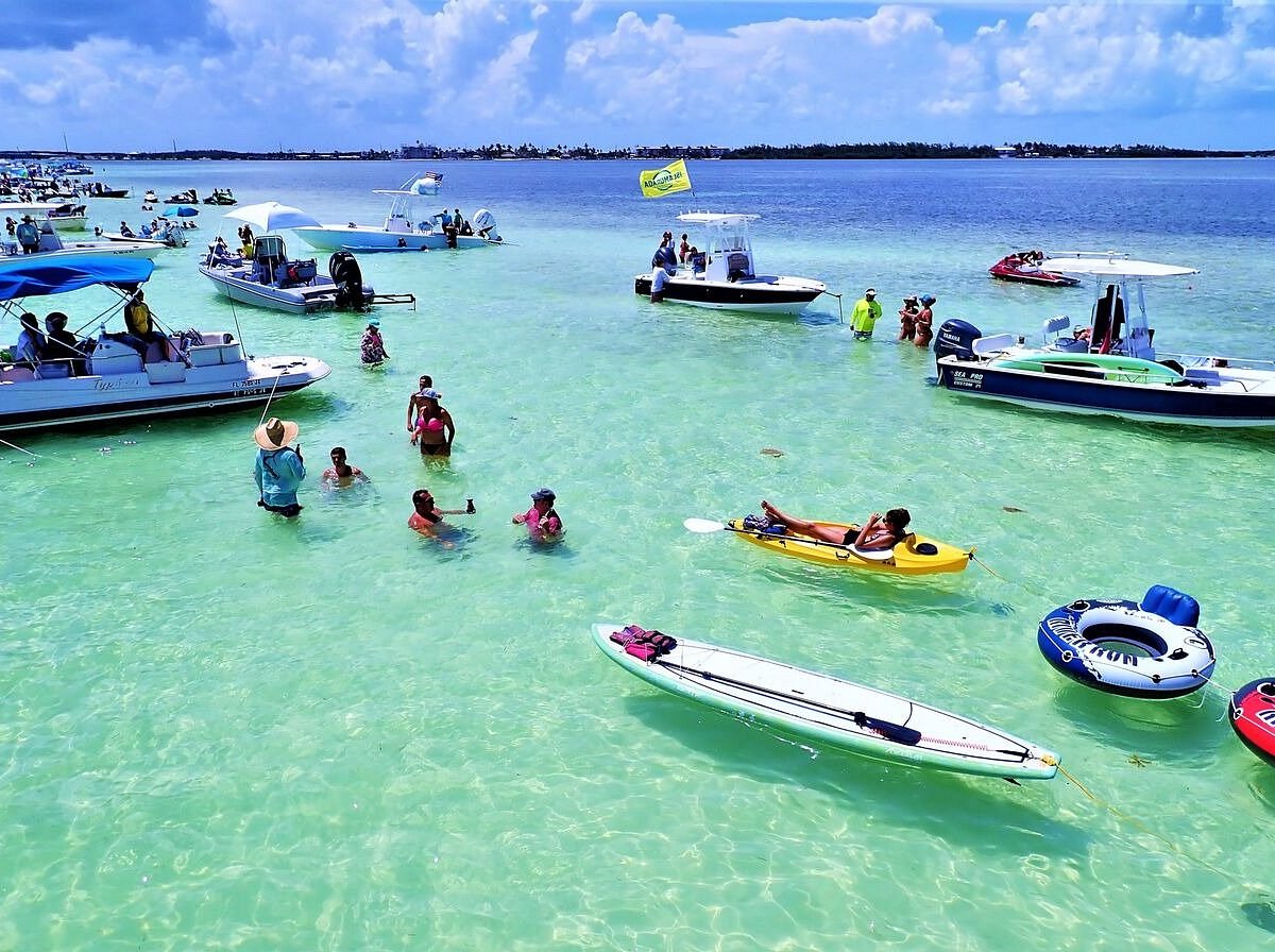
The sandbar forms where Atlantic currents slow against the reef line, depositing fine sand over centuries into a broad plateau that rises abruptly from surrounding depths of twelve to twenty feet. Most boaters locate it by departing from nearby marinas at Indian Key Fill or Snake Creek, following the Intracoastal Waterway to Channel Marker 45, then turning east-southeast toward open water. GPS coordinates cluster around 24.9247° N, 80.5891° W, though the sand's perimeter expands and contracts by hundreds of feet depending on lunar tides and storm activity. Approaching the Islamorada sandbar location demands attention to depth sounders and visual water-color shifts. The water transitions from deep blue to turquoise then milky jade as the bottom rises, signaling the sandbar's edge. Boaters anchor in five to eight feet along the periphery, wading or drifting onto the shallows rather than driving over them. During spring low tides, exposed sand creates temporary islands where visitors gather knee-deep in water. The formation has no fixed boundaries, no marked channels, and no lifeguard oversight. Navigation hazards include scattered coral heads south of the main flat, submerged grass flats to the west, and heavy weekend traffic that obscures depth perception. Local captains rely on polarized sunglasses to read the bottom, steering away from dark patches that indicate rock or dense turtle grass. The sandbar guide most boaters follow involves triangulating from the Alligator Reef Light three miles southeast and the Tea Table Relief Channel to the north, keeping Anne's Beach visible astern as a western reference point. Current and wind direction dictate anchorage strategy. Easterly trade winds push boats toward the reef, requiring upstream positioning, while westerlies create calmer conditions but crowd vessels onto the sandbar's lee side. Tidal flow reverses every six hours, so anchor scope must account for swing radius as boats pivot with the current. The sandbar remains accessible year-round, though summer afternoon thunderstorms and winter cold fronts create rough passages that strand inexperienced boaters offshore. No dock, no land access, and no permanent structure mark the site. Boaters depart from the same marinas that serve fishing charters and dive operations, making the sandbar location a destination for those already equipped with local waterway knowledge or guided by charter operators familiar with the reef's seasonal shifts.
“The water transitions from deep blue to turquoise then milky jade as the bottom rises, signaling the sandbar's edge.”
The Islamorada sandbar is located offshore near Mile Marker 84. Access is exclusively limited to private watercraft or commercial charter services, as there is no road or bridge connection to the site.
Private vessel or chartered tour from local marinas
Drive to Islamorada via Overseas Highway (US-1) to Mile Marker 84
Plan your arrival for the 08:00–12:00 window to ensure optimal water clarity and depth before the tide changes and afternoon crowds increase.
The best arrival window is 08:00–12:00 to ensure optimal water clarity and ideal depth conditions before afternoon crowds increase. Tides directly influence the usable surface area, making low tide during these morning hours the preferred time for sandbar access.
80°F to 85°F. Dry and clear conditions. Dry weather supports consistent water visibility for visitors.
78°F to 84°F. Occasional tropical systems. Early fall offers fewer crowds before winter arrivals.
—
Visiting midweek avoids the heavy recreational traffic common on weekends. Mornings provide the most calm and shallow water levels.
Verdict: The optimal experience occurs on weekday mornings between 08:00–12:00, particularly during the months of April or October.
Access to the Islamorada sandbar itself requires no admission fee. Expenses are solely associated with the boat transport or charter service required to reach the location.
Verdict: The entry fee is 0 USD, with total costs determined exclusively by the type of boat or charter service selected for transportation.
Navigating to the Islamorada sandbar requires attention to tides, proper anchoring technique, and environmental awareness. Most problems stem from inadequate preparation or disregard for marine habitat protection.
Arriving at high tide and running aground
Check NOAA tide charts before departure. The sandbar is best accessed during low to mid-tide when water depth is 1–3 feet, providing safe passage and comfortable wading.
Anchoring in seagrass beds and damaging habitat
Drop anchor only in sandy pockets, never over seagrass. Use a sand anchor or fluke anchor, and approach from the channel side to identify clear bottom before setting.
Ignoring no-wake zones near the sandbar approach
Reduce speed to idle within 300 feet of the sandbar and in marked channels. Excessive wake erodes the sandbar and disturbs wildlife in adjacent flats.
Failing to mark GPS coordinates for the return trip
Save waypoints for the sandbar location (near Mile Marker 84 offshore) and your launch point. Afternoon sun glare and changing water levels make visual navigation unreliable.
Underestimating current strength during tide changes
Plan your visit during slack tide periods between tidal shifts. Strong currents during incoming or outgoing tides create hazardous conditions for swimmers and complicate anchoring.
Sandbar trips require navigation tools, communication equipment, and gear to protect both yourself and the marine environment.
Everything you need to know about islamorada sandbar location
The islamorada sandbar location is situated offshore near Mile Marker 84 in the Florida Keys. Navigating to these coordinates requires careful attention to tides and shallow marine environments.
Access to the islamorada sandbar location is restricted to private vessels or chartered tours. Since there is no land access, planning your boat trip in advance is essential for a smooth arrival.
There is an entrance fee of 0 USD for the sandbar itself. While entry is free, you must arrange your own watercraft or book a charter to reach this landmark.
The best arrival window is 08:00–12:00 to experience optimal water clarity and depth at low tide. Arriving early also helps you avoid the afternoon peak crowds that often gather at the islamorada sandbar location.
When approaching this popular Florida landmark, maintain a slow speed and keep a sharp lookout for seagrass beds or local wildlife. Adhering to boating safety regulations ensures you protect the ecosystem while enjoying the turquoise views.
Families can enjoy the calm, shallow waters, but always keep children supervised while swimming or playing. Ensure you have proper safety gear on board your charter or private boat.
A common mistake is arriving during high tide or late afternoon when depths are higher and the area is more congested. Planning your visit according to the tide charts significantly improves your overall experience.